Pataeolian
Upset (The Power of the Patagonian Wind)
It was
misty and rainy at the end of the world. We rode 30 km of ripio through Tierra
Del Fuego National Park back to Ushuaia. There we gassed up and bought
groceries before returning to Graciela’s house in Rio Grande. We sent positive
thoughts to little Selena, the victim we had helped the previous week, as we
passed the crash sight. She had punched a hole in the windshield of her
mother’s car with her head. The car, probably with too much speed and while
attempting a left turn, had slipped on loose gravel and rolled in the ditch in
front of us. Argentina has a very high crash rate. Crashes have been a constant
throughout, and would continue to punctuate, our South American journey.
Graciela
greeted us with hugs and kisses, fresh coffee and crepes. Her stove and her
spirit warmed us. There was easy conversation throughout the evening before
Graciela went to work.
We had
about 100 km of ripio to do the next day. The crossing into Chile at the lonely
and windswept little station was brief and efficient. The ripio started immediately
and was easy this time. Our knobby tires dug into the gravel and grabbed the gnarly
hard-pack, providing good traction. The final section, 60 km to the Porvenir
ferry, was immediately of lesser quality. It steadily became worse. The gravel
was deep in places and made it tempting to go too slowly for the heavily banked
corners. Slippery gravel, steep banking and slow speeds on right handers made
one slide down into even deeper gravel at the base of the turn. Isabelle had
some difficulties with this.

In Porvenir Harbour
We
arrived in the bleak little town of Porvenir cold and tired. A trip to the
ferry dock revealed that there was only one trip per day and we had missed it.
Disappointment piled up as our first and second choices for lodging were closed
or closed down. We ended up paying top dollar for a lovely cabana. The luxury
was great but so was the guilt; five days worth of lodging budget blown in one
night!
We
chatted a bit with a couple next door who coincidentally were from Ottawa. They
had rented a 4X4 pick-up truck to tour the area. Michael said that he had read
how bad the section of road we had just ridden was. That road had motivated him
to splurge on a four-wheel drive vehicle from the rental agency.
I
serviced Isa’s chain after all that dust and gravel. The wind howled and was bitterly
cold. Task completed, I went inside. The gas fireplace radiated delightfully. We
watched TV while doing a couple of loads in the automatic laundry machine in
the kitchen. An evening walk to the only bank in town, in the only town we had
encountered so far in Chile, felt good and loosened our legs. We agreed to a
ten percent fee at the Cajero Automatico (ATM) and about 3% more with our bank but
our minds were eased, finally having Chilean Pesos in our pockets.

On the ferry
The ferry
ride was windy and rough. This second crossing of the Straight of Magellan,
from Tierra Del Fuego to the mainland, was wider than our previous crossing and
took two and a half hours. Luck was with us and we got seats at a table in the
lounge, despite the crowds. We shared the table with a cyclist names Paulo. We
would bump into him a couple of weeks later in El Calafate.
I checked
on the motos several times. The small ship was groaning, clanging and bucking
hard. Suspension compressing with each yaw, the motos really looked like they
were going to topple over. The crew had not tied them down yet. Crash bars on
the motos allow them to remain undamaged in a fall. The concern was that my
moto’s probable fall trajectory would put it on top of an expensive looking
bicycle. The crew eventually put blocks around the wheels and under the engine
skid plates in strategic locations. They had clearly done this before because
the bikes didn’t budge after they had finished.
Safe and
dry in Punta Arenas we found the hostel we were looking for. It was in my notes
as a recommended, bike friendly place that let you camp with kitchen
privileges. It also proved to be popular with backpackers. We stayed in the
overcrowded, overpriced place and put on a happy face. We met and had dinner
with a pleasant Dutch couple, Will and Garret. They are about our age. They too
said that the place was a fire hazard and they would be glad to rent their
pick-up truck and to move on the next day.
The ride
from Punta Arenas to Puerto Natales redefined the phrase, “worst wind ever” for
us. It came from the left (W) and tried to dump us into the ditch. We rode with
a large steering correction that caused the bike to lean sharply toward the
opposing lane. We developed the habit of slowing right down for passing trucks
and buses.
When a
cross-wind comes from the left, an oncoming large vehicle first hits you with
an explosive shockwave. Following immediately is a brief shelter from the
cross-wind. The shockwave rattles your brain and the wind shadow causes your
moto to jump violently toward the on-coming truck. Anticipating the necessary
and sudden release of the leftward steering correction takes practice. A
fraction of a frightening second later that steering correction needs to be
reapplied as one is struck by the blast of the return of the Patagonian wind. Reducing
our speed to 20 kph slows and reduces the effects. It gives us more room for
error, a fighting chance.

Spring flowers
The
“Yellow Plum Tent House” in Punta Arenas was a pleasant place to stay. It was a
little expensive but it was clean, modern and even at capacity, not
overcrowded. Carlos, the owner, had been a guide in Torres Del Paine National
Park. He seemed to enjoy pouring over maps and giving insightful hiking advice.

Blooms in a harsh climate
Numerous
tour company offices in town offered various bus/hike packages into the park,
80 km away. Carlos became excited over the fact that unlike the hoards of
backpackers in this touristic centre we have our own wheels. We told Carlos
that we had several days to spend in the park. He suggested a central
campground that did not require a reservation; from there, a series of day
hikes. We could ride to the trail heads on park roads. To train our bodies each
day the hikes would become longer and more challenging, leading to the hike
that would give a postcard view across a suspended lake to “Paine’s Towers” on
the final day.

Keeping warm in the south
Carlos
finished his thorough briefing by warning us to leave town with enough fuel for
a range of 500 km. Our jerry cans and red bottles raise our range to 600 km. He
showed me where to get fuel outside the park after taking a rough short-cut route
into Argentina.

Everywhere are signs of new growth
The
Yellow Plum breakfast was fabulous. We followed it with a shopping trip to buy
supplies for the week. We would need to be completely self-sufficient. The
town’s supermarket was really busy with customers wearing outdoor sporting
clothes and buying dried foods. We fit right in.

Approaching Parque Nacional Torres Del Paine
Following
Carlos’ advice, we then walked to the tourist office to pick up the best free map
I have ever seen; a full topo, waterproof map of the entire park. The map was
marked with all points of interest, trails and trailheads. It even showed spots
with elevated risk of high winds. We understood that trails were sometimes
closed due to high winds that could sweep people off of a mountain.

Guanaco Silhouette
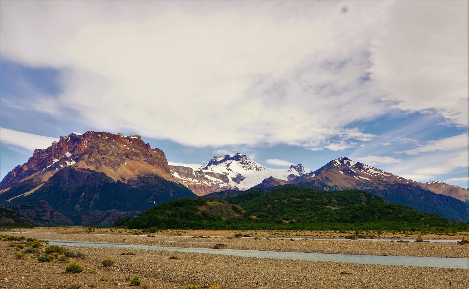
It was a
windy ride on Ruta 9 followed by 50 km of good ripio that brought us to the
campground. The relatively short ride took a long time because of the numerous
stops we felt compelled to make to take photos. The views were stunning. We
spent the first night at a site with the best view but with little shelter. The
wind drove us to a better sheltered site the next day.

The first campsite

The Second Campsite (see the orange tent?)

A Visitor to the Campground
Our first
hike was on the Mirador Condor trail. It was a blustery climb up the windward
side. There was a deep “V” between two peaks that created a venturi effect. The
focused wind in the venturi was “blow you off the mountain” strong. We crouched
low to reduce our profile to the wind but still our hiking boots slipped in the
gravel. Once again, our understanding of “the strongest wind possible” was
redefined. It would soon be further re-defined.

Summit of the Mirador El Condor Trail

Calm on the Lee Side
The first
of two hikes planned for the next day was closed due to high winds. The second
hike required a 45 km ride on park ripio roads to the trailhead. It gave views
of Lago Grey filled with turquoise, milky water. The trail followed a
kilometer-long gravel bar onto which white capped waves crashed noisily. Four
kilometers upwind lay Glaciar Grey. An hour and some climbing later the
glacier was more easily seen across the creamy blue Lago Grey. We opted not to
take the boat ride to the foot of the glacier. At $150 per person it was outside
our budget.

The gravel Bar

Glaciar Grey

Lago Grey Explained

Glacier Grey Explained
We
finished the day exploring some trails on the hills surrounding Pehoe Lake,
near our campground. The sun came out and the scenery hadn’t become “old” to
us. We were fascinated by the story book shapes and colours in the mountains. It
didn’t seem real. We couldn’t resist looking at them from every possible angle.
Sometimes we just sat on a comfortable rock and stared.

Lago Pehoe near our Campsite

Lago Pehoe with Paine's Towers behind

From the Hills Overlooking Lago Pehoe
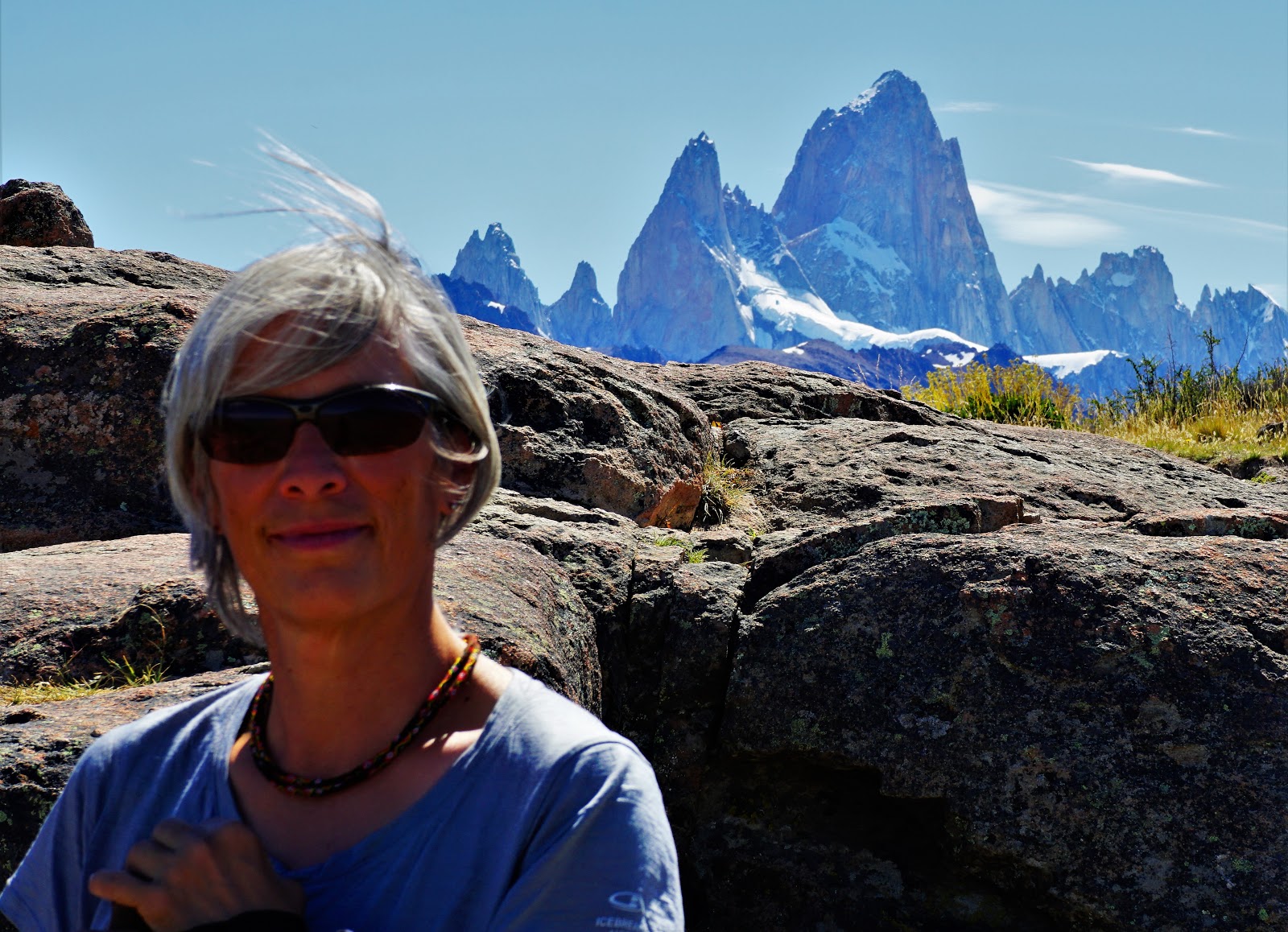
Mirador
Cuernos was the next hike. The sun was out that day and so was the wind. We
walked leaning sideways from time to time, our balance aided by our hiking
poles. Quadrupeds have superior traction and balance. We peeled off layers in
the 26-degree heatwave. This hike provided the closest views so far of the
towers. We were growing accustomed to the wind and our cranky old bodies were
building endurance capacity. Tomorrow would be the big hike with the postcard
view.

On the Trail to Mirador Cuernos

Mirador Cuernos
Alright,
the next day’s wind was the worst possible. We were 15 km into the ride to the
trailhead for the big hike. The wind was blowing just the right way into a
couple of narrowing valleys amongst the foot-hills. These natural venturis
focused and amplified the terrible gusts to unbelievable speeds. There were a
few bad corners that we survived by reacting quickly to the gusts, leaning into
the wind. Weaving our way through in low second gear worked alright for the
first few of them. Then it happened.
I
descended into a shallow valley. There was a left bend in the road at the
bottom before the ripio road rose again to the crest beyond. Just after
beginning the gentle left-hander I was slammed with a blast from the left. I
survived it by giving a large correction to the left.
“Really
strong left crosswind! Be ready to correct left”, I said into the mic.
“Wowa!”, came
back to me in the headset. A look in my mirror confirmed my fear. Isabelle
changed direction to the right in a hop and headed straight into the ditch, front
wheel first.
“Are you
OK?”, I asked
“Yeah,
I’m fine”, she answered, “I’m in the ditch.”
“I’m
coming to help”, I said preparing to stop. “I can’t stop here the wind is too
strong. It’ll knock me over. I’ll go over the top and find a place to stop. Are
you sure your OK?”
“Yup”
There was
a little parking space for a mirador over the crest of the hill. It was really
windy too. I parked into the wind hoping the bike would remain standing while I
was gone. At least it was off the road. The walk downhill and back to Isa felt
like a steep climb. Head down, leaning heavily forward my meandering path
finally got me there.
A bus had
stopped beside her. It was swaying back and forth a disturbing amount but it
was also providing a wind shadow for Isa and her moto. Two guides were off the
bus and had straightened out her bike in the ditch. It was in line with the
road again but in the deep loose stuff.
I swung a
leg over and tried to get the bike out of the ditch. Loose gravel spraying
behind, I got the bike up onto the road. Moving forward, the wind shadow from
the bus ended and a huge blast of wind slammed into my left side. I corrected,
leaning the bike over at an impossible angle. I was on the right-hand side of
the road crown. The tires slipped on the bad camber and loose gravel; the road
camber, slanting downwind and toward the ditch, offered reduced traction. It
was my turn for an ungraceful exit from the road.
“Is this
one of the times we decide to turn back?”, asked Isa, letting slip a little of
the stress she felt.
“Oh yeah”,
I answered “this is definitely unsafe. We’re lucky no one got hurt. I’ll turn your
bike around and park beside that little rise on the right. It should be
sheltered enough there for you to get back on it.”
I tried
the same method of climbing out of the ditch but this time the spinning rear
tire just dug a hole. Isa and the guides got on it and pushed me onto the road,
this time perpendicular and facing the wind. It was much easier to control the
moto. I climbed the road camber and rode over the crown before turning left.
Now the camber was in my favour and helped me to fight the force of the wind.
While
walking back to retrieve my moto the wind gusts seemed even stronger. I could
feel my boots slipping and realized I would soon be carried into the ditch.
Crouching to reduce exposure to the wind I used baby steps to get through the
worst of it. It was unbelievably powerful. As I pulled back onto the road with my
moto I saw two bicyclists riding toward the danger zone. I waited and warned
them to walk their bikes as they approach the top of the hill because of the
treacherous little valley beyond.
I made it
back to where Isa was waiting and we set off for our campsite. There would be
no hiking for us today. The wind was strong all the way back to camp. There
were three small zones that had particularly focused blasts.
We learned
that the wind gave warning of an approaching gust by throwing up clouds of
dust. Sometimes, there was a swirling dirt devil thrown into the mayhem. Each
wave lasted several seconds. Anticipating an air blast with the appropriate
lean helped reduce the surprise factor. Positioning ourselves on one side of
the road or the other, to use the natural camber of the road to advantage, gave
our tires a fighting chance at finding traction. Our technique improved and we
stayed upright.
A couple
of hours later, back at the campsite, a cyclist approached me asking for a butterfly
bandage. He had fallen in the wind and cut his eye lid. The bleeding had clearly
startled him but it had stopped on its own. The wound was completely closed. A
band aid would be tricky at best on a blinking eyelid. It was a minor cut, not
worth covering the whole eye. His vision was fine. Antiseptic cream and no
bandage seemed the best choice.
We
quickly established that he was one of the cyclists I had warned on the windy
road. He was Danish and was traveling south. I didn’t catch his name but we had
a lovely chat. He topped up my “must see and do” list for Patagonia with great
recent advice. He mentioned the detour on Carretera Austral was over 100 km
long and involved a ferry. Four months ago, there was a landslide accompanied
by tragic loss of life. The detour was still there when he passed through. He
thought the road might be open by the time we got there.
Jim and
Sue from Seattle invited over for a chat in the evening. They are close to us
in age. Their campsite was up the hill a little from ours, where the view of
the towers was spectacular. We sat with them in a spot that was well sheltered
from the relentless blow. They have been traveling for about three years. They
go back home periodically. We spent a couple of hours in easy conversation with
them. They are a lovely couple, kindred spirits.
A 4:30
alarm felt especially early. It had only been truly dark for about five hours
but light was already returning. We hoped to beat the wind with an early start
out of the park. We had decided to abandon the idea of the big hike. There was
no avoiding that dangerous little valley that had toppled us both. It was part
of the only way out of the park. The road to the south entrance was closed for
repairs. We steeled ourselves for trouble. Lago Pehoe was calm, hardly a wave
on it.
“Wasn’t
that our little valley back there?”, I asked into the mic fifteen minutes
later.
“Yes, I
think it was”, replied Isa with relief in her voice.

Leaving the Park
Our
stress levels immediately dropped and we began to enjoy the ride. The early
morning light was magical. The border crossing back into Argentina was quick
and easy. We took the short cut back to Ruta 40 that some say should be avoided
in the rain. The road was rather rough. We took it slowly, often in second
gear.
Up the
road we easily found our campground in El Calafate. The town is an upscale
version of Puerto Natales. It too has numerous outdoor gear stores, cafes and
restaurants but El Calafate has infrastructure to handle hundreds and hundreds
of tourists at a time. The big attraction is the Perito Moreno glacier. This
beautiful sight is a stop on any Patagonian itinerary. It is accessible by
paved road and is reported to be stunning.
We
encountered some French Swiss cyclists at the campground. We had met them at
the Yellow Plum in Puetro Natales. They had skipped Parque Nacional Torres Del
Paine. Apparently, the park has a reputation among riders for bad weather and
nasty wind… We also ran into Eric and Kathleen in the same campground. They had
stayed at Bertha’s for a short time in Sucre. We compared travel stories since
leaving Sucre. Eric said that they had seen us weeks before on Peninsula
Valdez. We appeared to be having a bad time on the Road of Marbles. Standing on
the bikes, we looked concentrated. They were in a rented car and he said it
sloshed around, skipping from track to track in the soup of stones. They had
spared us the extra stress of a friendly beep while passing.
I
discovered a loose windshield mount on my bike and rigged a temporary fix. One
of the plastic supporting parts was broken. I assume it was caused by the
powerful crosswinds that rattle the windshield so much. There is also a
fracture in Isabelle’s left-side panier mount. It needs welding. Cafes and
trekking stores can’t fix that. Surrounding these tourist towns are hundreds of
kilometers of Patagonian steppe without a building in sight.
Paolo, saving
$50 in bus fare, hitched a ride with us for the day trip to see the famous
Perito Moreno glacier. The glacier lies about an hour and a half west of town. He
is camped near us. We met him on the Porvenir ferry a few weeks ago. He cycled
up from Porvenir and this was his first stop. It seems many cyclists skip
Torres Del Paine because it is such a long detour off Ruta 40. It also has a
reputation for bad roads and foul weather.

Paolo with the Southern Tarn and Glacier Terminus Behind.
(You can see the peninsula of bedrock just above his GoPro)
The
Perito Moreno glacier is impressive and beautiful when viewed close up. The
site is very well managed and can easily accommodate the hundreds of tourists
it does each day without the environment being damaged in any way. A shuttle
bus brings loads of people from the parking lot to the beginning of the trails.
A series of raised steel trails allows viewing of the glacier from many
different angles without touching the ground. It’s a brilliant system covering
a few kilometers.

The Raised Trail System
A tarn is
a lake that can form at the natural limit of a healthy glacier. It is often
contained by a huge pile of end moraine but not in this case. Perito Moreno’s
milky, turquoise-coloured glacial melt-water is held back by surrounding towers
of bed-rock. The resulting tarn is very large and is in two parts. Separating
the two parts is a rounded peninsula of bedrock, on which we stood facing west.
The peninsula meets the glacier’s eastern endpoint. Lakes form left and right (south
and north) of this meeting point of bedrock and glacier.

Southern Tarn on the Left of Glacier Terminus

Northern Tarn on the Right of Glacier Terminus
Extended
periods containing high snowfall years can speed up the glacier’s flow rate.
When the glacier has a faster than normal flow rate ice is pushed against the bedrock
peninsula and forms a dam. The double tarn system can only drain to the right
(north), a few kilometers away. Uneven water levels in the two tarns results in
the creation of a stream between the glacier and the peninsula that flows left
to right, draining excess water from one tarn to the other. The traversing
stream serves to speed up calving of the glacier’s tip. This creates a natural
limit to the extent of the healthy glacier. The stream also serves to transport
away glacial till thereby stopping the formation of end moraine, at least for
the next little while.

Meeting Point of Peninsula and Glacier Terminus

A Newfoundlander would call this a "bergie bit". This one is in the northern Tarn.
The
raised steel trail system is so large that it is possible to find a quiet bench
for uninterrupted listening to the cracking and shifting of the ice flow. We
heard a huge noise as a “small” piece of ice, the size of a low-rise apartment
block, thundered and fell into the tarn. The sound immediately grabbed our
attention but the time delay caused us to see only the resulting waves.

Perito Moreno Glacier

Detail of the Crevasses
Another
great crash had us looking down the longest side of the glacier’s edge. We
missed the action of course, because of the time delay, but I thought I saw a
tall chunk of ice teetering above the splash. Continued staring at that spot
was soon rewarded. A few seconds later that tower of ice fell 70m into the
tarn. It was an impressive sight. The huge sound had many parts. The initial
cracking, as the solid piece of ice broke away, was followed by crashing and
break-up sounds. The tower pieces ricocheted off lower ice features on their
way to the tarn below. Then there was a thunderous slapping sound, as if caused
by a gigantic beaver-tail, but very much louder. The shock waves reached the
shore a few minutes later creating a second show of sight and sound. We really
enjoyed our day at the glacier.
"Fawlty Tower" Tumbling:


The ride
to El Chalten brought us across the Patagonian steppe with mountains in the
distance on our left. We stopped many times for photos beside beautiful lakes
and rivers of glacial run-off. The Patagonian wind was our constant companion.
It raced over waters that ranged in colour from powder blue, through milky
turquoise to deep blue.

Lago Viedma
Heading
north on the famous Ruta 40 there was almost no traffic. This now largely paved
rural route connects tiny communities from north to south along Argentina’s
western side. Nicknamed, “The Spine of the Country” it is more than 5,000
kilometers long and is considered to be Argentina’s “Route 66”. We passed the
occasional cyclists, mostly in pairs. We really respect them and always give them
an encouraging wave. One couple was stopped and looked discouraged about
fighting the wind. It must be terribly tough.

Rugged Beauty in Patagonia
El
Chalten calls its self “The Hiking Capital of Patagonia”. It certainly is
popular. There are many people and a density of highly priced services for
them. The first campground we looked at was right at the road and looked like a
parking lot full of tents. The second one was more inviting and less crowded.
It was overpriced but it would do. We were cold and tired from battling with
the Patagonian wind all day.

Approaching El Chalten
I went
for a reconnaissance ride the next morning. The first stop was the tourist
office where the young woman gave me a map and trails advice. I continued
north, out of town on a gravel road. I was looking for better camping and for
an alternative trailhead for the “Lago de los Tres” trail that would take us to
the glacier on Mount Fitzroy.
Scenes from the Reconnaissance Ride:


The road
became rougher as I went on. I found a great campground that was almost empty.
It was beautifully placed at a sheltered bend in the river and had great
features. It was 10k away from town so not accessible by walking from the bus
station. This and the fact that there was no wifi meant that the place wasn’t
crowded with young backpackers. We talked about it and considered relocating. Faced
with the task of re-packing and riding a rough gravel road, we decided not to go
to the trouble of moving but will remember the lesson – get away from
overcrowding by getting beyond walking distance of the bus station.
Scenes from the First Hike:


We took
two smaller hikes today, each one giving fabulous views of the surrounding
mountains. We shared the meadows with some healthy-looking cows. The big hike
will be tomorrow. It covers 20k and rises about 700m. It will be a long one.
The “Lago
de Los Tres” hike begins at the north end of the village. We started at 10:30
in the morning to let the strong sun warm up the air a bit. It gets dark at
10:30 and we allowed ourselves 10 hours for the hike. There were so many jaw
dropping views along the way that we lost count of them. The last kilometer
took a whole hour. It was a steep ascent over loose ground. The trail switched
back repeatedly as it brought one up the massive dam of end moraine that held
in the glacial tarn above. There was a shelter and rest area where we ate a
late lunch to gain strength for the final push.
Scenes from Early in the Lago de Los Tres Hike:


Some people will do anything to get their photo taken.
A sign
posted in Spanish and English at the rest area gave warning about the
difficulty of the final kilometer. It said that the trail could have high winds,
was covered in loose material and required good physical conditioning. We saw
people experiencing difficulty, despite the warnings. Some of them slipped on
the steep glacial till during the ultimate kilometer. A couple was stuck in
place with one of them frozen in fear. The young woman was covered in dust. Her
partner was trying to reassure her. We imagined that she had fallen one too
many times for her nerves to bear. Equipped with good boots and hiking poles
and having experienced New Hampshire’s challenging White Mountains we found the
trail to be of medium difficulty.
Slowly Approaching the Pointed Giants:


The trail
ends on top of a huge pile of end moraine that hold back a milky turquoise
tarn. The glacier’s end is actually a little higher than the final tarn and
run-off has created a smaller, suspended tarn contained by exposed bedrock.

Standing on Top of the End Moraine

The Tarn and Glacier Terminus at Cerro Fitz Roy

Neighboring Peaks
It was
worth the effort it took to get there. That day’s hike was easily our favorite one
of the trip so far. We hiked 10 km back to the village. It was mostly downhill
so we covered it in a much shorter time than the ascent had required. We treated
ourselves to an expensive dinner near our awaiting warm beds. Sleep came
easily.
We hoped
an early start the next day would give us some riding time northward, without
wind. We were particularly concerned about a 75 km section of ripio with a bad
reputation. The ripio begins 125 km outside of El Chalten. The wind was our
companion, strong and loyal, from the beginning of the ride. We have learned to
manage it on tarmac. On gravel, the wind would literally cause our downfall.
We aired
down our tires for better traction and the first 32k of ripio went well. The
condition of the ripio was reasonable. The wind was from the left and easily
tossed us around. It was in the next 5k that things went wrong.

Reasonably Good Ripio at the Beginning
The worst
part of a stretch of bad road always seems to be in the middle. The middle
section of this patch of ripio on Ruta 40 has deep rounded pebbles, just like
the “Road of Marbles” on Penisula Valdez. We were crawling along in first gear
when a big gust of wind blew over Isabelle’s moto. The side panier caught her
foot and twisted her ankle, the left one this time. She didn’t know it until
later but, you guessed it, she had fractured it.
Her ankle
didn’t really hurt that much so tough Isa decided to ride it out. The deep
gravel seemed impossible to navigate in the relentless blasts of wind so we got
through that tough section by getting completely off the road. The shallow
ditch was bone-dry and offered good traction. We putted along in first gear. When
it got rough in the ditch we simply rode further away from the road and onto
the flat Patagonian steppe. It was hard packed mud and gravel. It would have
been a nightmare in the rain but it was a perfect surface for riding that day.
A few kilometers later the deep gravel finished and the road became normal ripio
again.

True Grit: Isabelle Reaches the End of the Ripio
Twenty-five
kilometers later there was blacktop. Seventy-five kilometers after that we made
it to the town of Gobernador Gregores, without further incident. A visit to the
hospital the next day confirmed our suspicion. X-rays revealed she had a small break in her ankle and no bone damage to her knee. Her chain smoking doctor
wrote her a chit prescribing a Velcro boot and crutches combined with 25 days
of rest before riding a motorcycle. Thanks, and a handshake were the only
payment required. Medical care is free for all in Argentina. We began the
search for long term lodging the next day. Here we go again.


